| at: |
Rock Creek/Tatum Lead ORV Trails Mulberry Gap |
Data from David Muse
 show on map
 animate
Trail users:


Elevation Profile
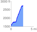
 2.671419 mi
 1420.68 ft
 187.56 ft
 1233.13 ft
 10.07 %
GPX Downloads: Track Route
Trailheads:
 Rock Creek ORV Parking Lot