| at: |
Kisatchie National Forest - Caney District |
Data from USFS GIS
 show on map
 animate
Trail users:


Elevation Profile
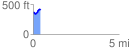
 0.435295 mi
 86.99 ft
 48.90 ft
 38.09 ft
 3.78 %
GPX Downloads: Track Route
![]()
| at: |
Kisatchie National Forest - Caney District |
show on map
animate
0.435295 mi
86.99 ft
48.90 ft
38.09 ft
3.78 %