| at: |
Kisatchie National Forest - Caney District |
Data from USFS GIS
 show on map
 animate
Trail users:


Elevation Profile
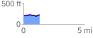
 1.330346 mi
 93.25 ft
 79.02 ft
 14.23 ft
 1.33 %
GPX Downloads: Track Route
![]()
| at: |
Kisatchie National Forest - Caney District |
show on map
animate
1.330346 mi
93.25 ft
79.02 ft
14.23 ft
1.33 %