| at: |
Kisatchie National Forest - Caney District |
Data from USFS GIS
 show on map
 animate
Trail users:


Elevation Profile
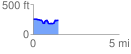
 1.455760 mi
 128.08 ft
 154.91 ft
 -26.83 ft
 2.02 %
GPX Downloads: Track Route
![]()
| at: |
Kisatchie National Forest - Caney District |
show on map
animate
1.455760 mi
128.08 ft
154.91 ft
-26.83 ft
2.02 %