| at: |
Kisatchie National Forest - Caney District |
Data from USFS GIS
 show on map
 animate
Trail users:


Elevation Profile
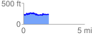
 2.071966 mi
 312.03 ft
 298.61 ft
 13.42 ft
 2.85 %
GPX Downloads: Track Route
![]()
| at: |
Kisatchie National Forest - Caney District |
show on map
animate
2.071966 mi
312.03 ft
298.61 ft
13.42 ft
2.85 %