| at: |
Kisatchie National Forest - Winn/Catahoula Districts |
Data from USFS GIS
 show on map
 animate
Trail users:


Elevation Profile
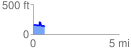
 0.696676 mi
 71.90 ft
 98.78 ft
 -26.89 ft
 2.69 %
GPX Downloads: Track Route
![]()
| at: |
Kisatchie National Forest - Winn/Catahoula Districts |
show on map
animate
0.696676 mi
71.90 ft
98.78 ft
-26.89 ft
2.69 %