| at: |
Kisatchie National Forest - Winn/Catahoula Districts |
Data from USFS GIS
 show on map
 animate
Trail users:


Elevation Profile
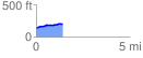
 1.423152 mi
 86.07 ft
 28.16 ft
 57.91 ft
 1.15 %
GPX Downloads: Track Route
![]()
| at: |
Kisatchie National Forest - Winn/Catahoula Districts |
show on map
animate
1.423152 mi
86.07 ft
28.16 ft
57.91 ft
1.15 %