| at: |
Kisatchie National Forest - Winn/Catahoula Districts |
Data from USFS GIS
 show on map
 animate
Trail users:


Elevation Profile
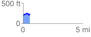
 0.595953 mi
 68.27 ft
 38.94 ft
 29.34 ft
 2.17 %
GPX Downloads: Track Route
![]()
| at: |
Kisatchie National Forest - Winn/Catahoula Districts |
show on map
animate
0.595953 mi
68.27 ft
38.94 ft
29.34 ft
2.17 %