| at: |
Kisatchie National Forest - Winn/Catahoula Districts |
Data from USFS GIS
 show on map
 animate
Trail users:


Elevation Profile
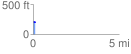
 0.144101 mi
 3.69 ft
 15.37 ft
 -11.68 ft
 2.02 %
GPX Downloads: Track Route
![]()
| at: |
Kisatchie National Forest - Winn/Catahoula Districts |
show on map
animate
0.144101 mi
3.69 ft
15.37 ft
-11.68 ft
2.02 %