|
| at: |
Kisatchie National Forest - Kisatchie District |
Data from USFS GIS
 show on map
 animate
Trail users:


Elevation Profile
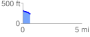
 0.637361 mi
 22.20 ft
 101.49 ft
 -79.29 ft
 3.02 %
GPX Downloads: Track Route
![]()
|
| at: |
Kisatchie National Forest - Kisatchie District |
show on map
animate
0.637361 mi
22.20 ft
101.49 ft
-79.29 ft
3.02 %