| at: |
Kisatchie National Forest - Kisatchie District |
Data from USFS GIS
 show on map
 animate
Trail users:


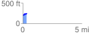
Elevation Profile
 0.336155 mi
 71.23 ft
 7.69 ft
 63.54 ft
 4.01 %
GPX Downloads: Track Route
![]()
| at: |
Kisatchie National Forest - Kisatchie District |
show on map
animate
0.336155 mi
71.23 ft
7.69 ft
63.54 ft
4.01 %