|
| at: |
Kisatchie National Forest - Kisatchie District |
Data from USFS GIS
 show on map
 animate
Trail users:


Elevation Profile
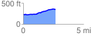
 2.688206 mi
 170.06 ft
 54.03 ft
 116.03 ft
 1.20 %
GPX Downloads: Track Route
![]()
|
| at: |
Kisatchie National Forest - Kisatchie District |
show on map
animate
2.688206 mi
170.06 ft
54.03 ft
116.03 ft
1.20 %