|
| at: |
Kisatchie National Forest - Kisatchie District |
Data from USFS GIS
 show on map
 animate
Trail users:


Elevation Profile
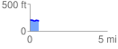
 0.579751 mi
 16.87 ft
 38.79 ft
 -21.92 ft
 1.27 %
GPX Downloads: Track Route
![]()
|
| at: |
Kisatchie National Forest - Kisatchie District |
show on map
animate
0.579751 mi
16.87 ft
38.79 ft
-21.92 ft
1.27 %