|
| at: |
Kisatchie National Forest - Kisatchie District |
Data from USFS GIS
 show on map
 animate
Trail users:


Elevation Profile
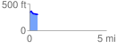
 0.547334 mi
 40.76 ft
 64.16 ft
 -23.40 ft
 2.22 %
GPX Downloads: Track Route
![]()
|
| at: |
Kisatchie National Forest - Kisatchie District |
show on map
animate
0.547334 mi
40.76 ft
64.16 ft
-23.40 ft
2.22 %