|
| at: |
Kisatchie National Forest - Kisatchie District |
Data from USFS GIS
 show on map
 animate
Trail users:


Elevation Profile
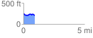
 0.935759 mi
 63.98 ft
 111.30 ft
 -47.32 ft
 2.25 %
GPX Downloads: Track Route
![]()
|
| at: |
Kisatchie National Forest - Kisatchie District |
show on map
animate
0.935759 mi
63.98 ft
111.30 ft
-47.32 ft
2.25 %