| at: |
Kisatchie National Forest - Kisatchie District |
Data from USFS GIS
 show on map
 animate
Trail users:


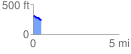
Elevation Profile
 0.484429 mi
 14.72 ft
 86.61 ft
 -71.89 ft
 3.39 %
GPX Downloads: Track Route
![]()
| at: |
Kisatchie National Forest - Kisatchie District |
show on map
animate
0.484429 mi
14.72 ft
86.61 ft
-71.89 ft
3.39 %