| at: |
Kisatchie National Forest - Kisatchie District |
Data from USFS GIS
 show on map
 animate
Trail users:


Elevation Profile
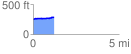
 1.242898 mi
 86.99 ft
 40.92 ft
 46.06 ft
 1.33 %
GPX Downloads: Track Route
![]()
| at: |
Kisatchie National Forest - Kisatchie District |
show on map
animate
1.242898 mi
86.99 ft
40.92 ft
46.06 ft
1.33 %