|
| at: |
Kisatchie National Forest - Kisatchie District |
Data from USFS GIS
 show on map
 animate
Trail users:


Elevation Profile
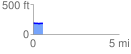
 0.580865 mi
 12.03 ft
 16.80 ft
 -4.77 ft
 0.55 %
GPX Downloads: Track Route
![]()
|
| at: |
Kisatchie National Forest - Kisatchie District |
show on map
animate
0.580865 mi
12.03 ft
16.80 ft
-4.77 ft
0.55 %