|
| at: |
Kisatchie National Forest - Kisatchie District |
Data from USFS GIS
 show on map
 animate
Trail users:


Elevation Profile
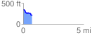
 0.731809 mi
 20.06 ft
 146.89 ft
 -126.83 ft
 3.80 %
GPX Downloads: Track Route
![]()
|
| at: |
Kisatchie National Forest - Kisatchie District |
show on map
animate
0.731809 mi
20.06 ft
146.89 ft
-126.83 ft
3.80 %