| at: |
Kisatchie National Forest - Kisatchie District |
Data from USFS GIS
 show on map
 animate
Trail users:


Elevation Profile
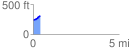
 0.421048 mi
 71.42 ft
 0.62 ft
 70.81 ft
 3.21 %
GPX Downloads: Track Route
![]()
| at: |
Kisatchie National Forest - Kisatchie District |
show on map
animate
0.421048 mi
71.42 ft
0.62 ft
70.81 ft
3.21 %