|
| at: |
Kisatchie National Forest - Kisatchie District |
Data from USFS GIS
 show on map
 animate
Trail users:


Elevation Profile
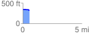
 0.565983 mi
 6.69 ft
 32.24 ft
 -25.55 ft
 1.08 %
GPX Downloads: Track Route
![]()
|
| at: |
Kisatchie National Forest - Kisatchie District |
show on map
animate
0.565983 mi
6.69 ft
32.24 ft
-25.55 ft
1.08 %