|
| at: |
Kisatchie National Forest - Kisatchie District |
Data from USFS GIS
 show on map
 animate
Trail users:


Elevation Profile
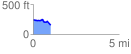
 1.033008 mi
 40.50 ft
 141.53 ft
 -101.04 ft
 2.59 %
GPX Downloads: Track Route
![]()
|
| at: |
Kisatchie National Forest - Kisatchie District |
show on map
animate
1.033008 mi
40.50 ft
141.53 ft
-101.04 ft
2.59 %