| at: |
Kisatchie National Forest - Kisatchie District |
Data from USFS GIS
 show on map
 animate
Trail users:


Elevation Profile
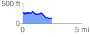
 2.488657 mi
 223.49 ft
 333.02 ft
 -109.53 ft
 2.53 %
GPX Downloads: Track Route
![]()
| at: |
Kisatchie National Forest - Kisatchie District |
show on map
animate
2.488657 mi
223.49 ft
333.02 ft
-109.53 ft
2.53 %