|
| at: |
Kisatchie National Forest - Kisatchie District |
Data from USFS GIS
 show on map
 animate
Trail users:


Elevation Profile
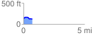
 0.735093 mi
 34.70 ft
 58.24 ft
 -23.54 ft
 1.50 %
GPX Downloads: Track Route
![]()
|
| at: |
Kisatchie National Forest - Kisatchie District |
show on map
animate
0.735093 mi
34.70 ft
58.24 ft
-23.54 ft
1.50 %