|
| at: |
Kisatchie National Forest - Kisatchie District |
Data from USFS GIS
 show on map
 animate
Trail users:


Elevation Profile
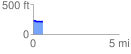
 0.554142 mi
 7.51 ft
 29.28 ft
 -21.78 ft
 1.00 %
GPX Downloads: Track Route
![]()
|
| at: |
Kisatchie National Forest - Kisatchie District |
show on map
animate
0.554142 mi
7.51 ft
29.28 ft
-21.78 ft
1.00 %