| at: |
Kisatchie National Forest - Kisatchie District |
Data from USFS GIS
 show on map
 animate
Trail users:


Elevation Profile
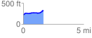
 1.653540 mi
 128.93 ft
 31.95 ft
 96.98 ft
 1.48 %
GPX Downloads: Track Route
![]()
| at: |
Kisatchie National Forest - Kisatchie District |
show on map
animate
1.653540 mi
128.93 ft
31.95 ft
96.98 ft
1.48 %