|
| at: |
Kisatchie National Forest - Kisatchie District |
Data from USFS GIS
 show on map
 animate
Trail users:


Elevation Profile
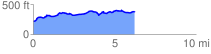
 6.307058 mi
 461.15 ft
 291.83 ft
 169.32 ft
 1.38 %
GPX Downloads: Track Route
![]()
|
| at: |
Kisatchie National Forest - Kisatchie District |
show on map
animate
6.307058 mi
461.15 ft
291.83 ft
169.32 ft
1.38 %