|
| at: |
Sumter National Forest - Enoree District Enoree OHV Trail |
Data from USFS GIS
 show on map
 animate
Trail users:


Elevation Profile
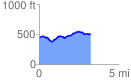
 3.259646 mi
 264.64 ft
 218.04 ft
 46.60 ft
 1.54 %
GPX Downloads: Track Route
![]()
|
| at: |
Sumter National Forest - Enoree District Enoree OHV Trail |
show on map
animate
3.259646 mi
264.64 ft
218.04 ft
46.60 ft
1.54 %