| at: |
Buncombe Trails Sumter National Forest - Enoree District |
Data from USFS GIS
 show on map
 animate
Trail users:


Elevation Profile
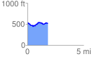
 1.855215 mi
 228.80 ft
 230.23 ft
 -1.42 ft
 2.35 %
GPX Downloads: Track Route
![]()
| at: |
Buncombe Trails Sumter National Forest - Enoree District |
show on map
animate
1.855215 mi
228.80 ft
230.23 ft
-1.42 ft
2.35 %