| at: |
Sumter National Forest - Enoree District Enoree OHV Trail |
Data from USFS GIS
 show on map
 animate
Trail users:


Elevation Profile
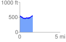
 1.608356 mi
 186.26 ft
 185.50 ft
 0.76 ft
 2.19 %
GPX Downloads: Track Route
![]()
| at: |
Sumter National Forest - Enoree District Enoree OHV Trail |
show on map
animate
1.608356 mi
186.26 ft
185.50 ft
0.76 ft
2.19 %