|
| at: |
Francis Marion National Forest |
Data from USFS GIS
 show on map
 animate
Trail users:


Elevation Profile
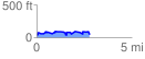
 2.767240 mi
 242.13 ft
 247.68 ft
 -5.55 ft
 1.70 %
GPX Downloads: Track Route
![]()
|
| at: |
Francis Marion National Forest |
show on map
animate
2.767240 mi
242.13 ft
247.68 ft
-5.55 ft
1.70 %