|
| at: |
Francis Marion National Forest Ion Swamp Interpretive Trail |
Data from USFS GIS
 show on map
 animate
Trail users:

Elevation Profile
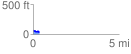
 0.367716 mi
 26.60 ft
 49.64 ft
 -23.05 ft
 2.56 %
GPX Downloads: Track Route
![]()
|
| at: |
Francis Marion National Forest Ion Swamp Interpretive Trail |
show on map
animate
0.367716 mi
26.60 ft
49.64 ft
-23.05 ft
2.56 %