|
| at: |
Sumter National Forest - Andrew Pickens District |
Data from USFS GIS
 show on map
 animate
Trail users:


Elevation Profile
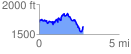
 2.779477 mi
 728.86 ft
 794.09 ft
 -65.23 ft
 5.41 %
GPX Downloads: Track Route
![]()
|
| at: |
Sumter National Forest - Andrew Pickens District |
show on map
animate
2.779477 mi
728.86 ft
794.09 ft
-65.23 ft
5.41 %