| at: |
West Georgia Pinhoti Johns Mountain WMA James H. Floyd State Park |
Data from David Muse
 show on map
 animate
Trail users:


Elevation Profile
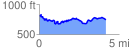
 4.178434 mi
 498.80 ft
 567.37 ft
 -68.57 ft
 2.57 %
GPX Downloads: Track Route