| at: |
South Fork |
Data from Positive Flow
 show on map
 animate
Trail users:


Elevation Profile
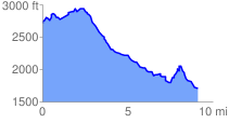
 9.178510 mi
 1210.39 ft
 2203.39 ft
 -993.00 ft
 4.55 %
GPX Downloads: Track Route
![]()
| at: |
South Fork |
show on map
animate
9.178510 mi
1210.39 ft
2203.39 ft
-993.00 ft
4.55 %