|
| at: |
North Oconee National Forest |
Data from David Muse
 show on map
 animate
Trail users:


Elevation Profile
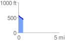
 0.581717 mi
 10.52 ft
 134.70 ft
 -124.18 ft
 4.39 %
GPX Downloads: Track Route
![]()
|
| at: |
North Oconee National Forest |
show on map
animate
0.581717 mi
10.52 ft
134.70 ft
-124.18 ft
4.39 %