| at: |
Cheaha State Park |
Data from David Muse
 show on map
 animate
Trail users:


Elevation Profile
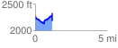
 1.171074 mi
 325.25 ft
 311.15 ft
 14.09 ft
 5.26 %
GPX Downloads: Track Route
Trailheads:
 Cheaha State Park
![]()
| at: |
Cheaha State Park |
show on map
animate
1.171074 mi
325.25 ft
311.15 ft
14.09 ft
5.26 %
Cheaha State Park