| at: |
Fort Ord Public Lands |
Data from David Muse
 show on map
 animate
Trail users:


Elevation Profile
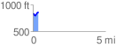
 0.389995 mi
 73.90 ft
 48.70 ft
 25.20 ft
 3.59 %
GPX Downloads: Track Route
![]()
| at: |
Fort Ord Public Lands |
show on map
animate
0.389995 mi
73.90 ft
48.70 ft
25.20 ft
3.59 %