| at: |
Lake Norman State Park |
Data from Positive Flow
 show on map
 animate
Trail users:


Elevation Profile
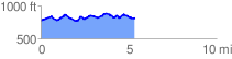
 5.449591 mi
 636.29 ft
 630.83 ft
 5.46 ft
 2.21 %
GPX Downloads: Track Route
![]()
| at: |
Lake Norman State Park |
show on map
animate
5.449591 mi
636.29 ft
630.83 ft
5.46 ft
2.21 %