|
| at: |
Rich Mountain |
Data from David Muse
 show on map
 animate
This road is marked FS259 on maps and in the field, but is marked FS295 in USFS GIS data.
Trail users:


Elevation Profile
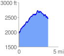
 3.770278 mi
 1346.92 ft
 804.28 ft
 542.64 ft
 6.77 %
GPX Downloads: Track Route