| at: |
Bear Creek/Mountaintown |
Data from USFS GIS
 show on map
 animate
Trail users:

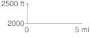
Elevation Profile
 0.038197 mi
 10.05 ft
 29.98 ft
 -19.93 ft
 14.87 %
GPX Downloads: Track Route
![]()
| at: |
Bear Creek/Mountaintown |
show on map
animate
0.038197 mi
10.05 ft
29.98 ft
-19.93 ft
14.87 %