|
| at: |
North Oconee National Forest |
Data from USFS GIS
 show on map
 animate
Trail users:


Elevation Profile
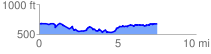
 7.765689 mi
 786.93 ft
 786.54 ft
 0.39 ft
 1.92 %
GPX Downloads: Track Route
![]()
|
| at: |
North Oconee National Forest |
show on map
animate
7.765689 mi
786.93 ft
786.54 ft
0.39 ft
1.92 %