| at: |
Breckenridge |
Data from Positive Flow
 show on map
 animate
Trail users:


Elevation Profile
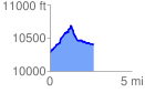
 2.661991 mi
 482.46 ft
 361.38 ft
 121.08 ft
 3.43 %
GPX Downloads: Track Route
![]()
| at: |
Breckenridge |
show on map
animate
2.661991 mi
482.46 ft
361.38 ft
121.08 ft
3.43 %