| at: |
Santos |
Data from USFS GIS
 show on map
 animate
Trail users:


Elevation Profile
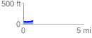
 0.814627 mi
 55.14 ft
 38.71 ft
 16.42 ft
 1.28 %
GPX Downloads: Track Route
![]()
| at: |
Santos |
show on map
animate
0.814627 mi
55.14 ft
38.71 ft
16.42 ft
1.28 %