|
| at: |
Tray Mountain |
Data from USFS GIS
 show on map
 animate
Marked as FS305 on USFS Maps and GIS data but marked as FS698 in the field.
Trail users:


Elevation Profile
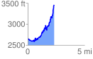
 2.343508 mi
 1185.53 ft
 381.63 ft
 803.90 ft
 9.58 %
GPX Downloads: Track Route