|
| at: |
Pinelog WMA |
Data from David Muse
 show on map
 animate
Until late-2017/early-2018, the section of this road from Stamp Creek Road, clockwise to Donahue Road was known as the Main Road. The ungated section of Donahue Road, and the road leading a ways up the ridge toward Hanging Mountain was also part of the Main Road.
Sometime prior to 2017, the section of this road, from Stamp Creek Road, counter-clockwise to some undefined point north of Poplar Pit road was known as Cotton Patch Road.


Elevation Profile
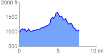
 7.872205 mi
 1232.64 ft
 1158.12 ft
 74.52 ft
 2.97 %
GPX Downloads: Track Route
Trailheads:
 Pine Log Parking Lot