 show on map
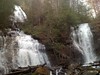
This falls was once instrumental in the Byrd-Matthews Lumber Companys operations in the area.
Logs were skidded to the top of the falls, loaded into a flume that looped around the face of the falls, picked up somewhere below and conveyed to the mill in Helen via light-gauge rail.
The exact start and end points of the flume and location of the rail are unknown and beg investigation.
Anna Ruby Falls
The Riverkeepers Guide to the Chattahoochee
Coords: 34.763694 N -83.712172 W
GPX Downloads: Waypoint