 show on map
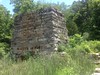


Built in the 1840s by Charles W. Howard. Operated under the Howard Cement Company. The surrounding area was once known as the town of Cement, which still appears on some modern topo maps.
Production was limited until post-civil-war.
In 1889 Howard sold the plant to his son-in-law, George H. Waring, who operated it under the Howard Hydraulic Cement Company and increased production significantly. The company produced cement until 1910 or 1912.
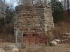
There were once 6 kilns on site or nearby. Currently, only 2 stand: a double-kiln, and part of one of the circular kilns.
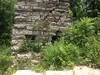
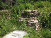
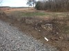
The basement of some structure to the north of the kilns is visible from the road, or from the tracks. There is also a rock wall visible along the tracks.
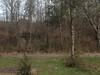
The entire area is extremely overgrown, so much so that nothing but the double-kiln and rock wall are visible except in winter.
To the south, if you dig through the brush, the ruins of a cylindrical brick shaft are visible. I wonder if it was a smaller, cylindrical kiln. Unfortunately, no old photos show that part of the structure.
Cement
Ruins of Howard Cement Company
Coords: 34.258538 N -84.959236 W
GPX Downloads: Waypoint