| at: |
Blue Ridge WMA |
Data from David Muse
 show on map
 animate
Route users:

Elevation Profile
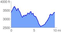
 9.586218 mi
 2344.13 ft
 2350.73 ft
 -6.60 ft
GPX Downloads: Track Route
![]()
| at: |
Blue Ridge WMA |
show on map
animate
9.586218 mi
2344.13 ft
2350.73 ft
-6.60 ft