| at: |
Blue Ridge WMA |
Data from David Muse
 show on map
 animate
Route users:

Elevation Profile
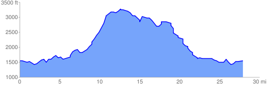
 28.517347 mi
 4934.38 ft
 4934.38 ft
 0.00 ft
GPX Downloads: Track Route
![]()
| at: |
Blue Ridge WMA |
show on map
animate
28.517347 mi
4934.38 ft
4934.38 ft
0.00 ft